


Today’s topic is subsurface utility engineering trends. Deep Research proposed and executed the following research plan:
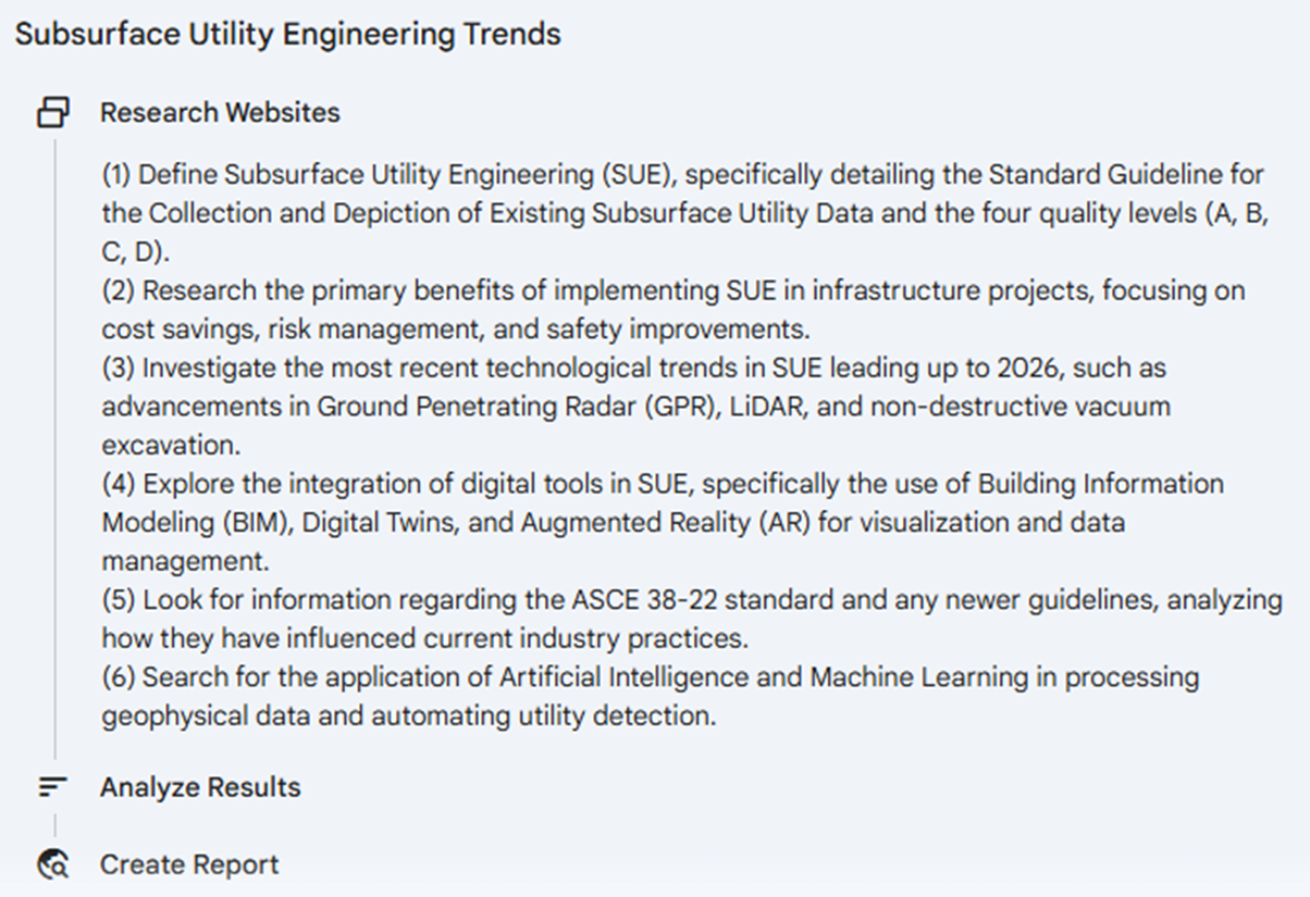 Gemini Deep Research’s Plan of Attack
Here’s the summary of Deep Research’s report:
-Deep Research Report Summary Start-
Subsurface Utility Engineering: Unveiling the Underground
Subsurface Utility Engineering (SUE) has evolved from a niche locating service into a critical engineering discipline essential for modern infrastructure development. It addresses the "invisible infrastructure crisis"—the vast, often undocumented network of pipes and cables beneath our cities. By integrating civil engineering, geophysics, and surveying, SUE manages the risks associated with underground utilities, replacing the reliance on inaccurate historical records with empirical data.
The Regulatory Backbone: ASCE 38-22
The foundation of the discipline is the ASCE 38-22 standard, which classifies utility data into four Quality Levels (QL) ranging from QL-D (records research) to QL-A (precise vacuum excavation). The 2022 update significantly modernized the practice by emphasizing the role of the "Professional in Responsible Charge" and creating specific protocols for 3D modelling and digital data exchange. This shift ensures that utility data is treated with the same engineering rigor as structural or geotechnical elements.
The Economic Case
The return on investment (ROI) for SUE is well-documented and substantial. A landmark Purdue University study established a benchmark savings of .62 for every .00 spent, while a Pennsylvania State University study found returns as high as .21. More recent data from the Louisiana Department of Transportation (2021) confirms that complex projects yield significant savings by avoiding utility strikes, reducing contractor claims, and preventing costly redesigns.
Technological Transformation
The most dynamic recent trends in SUE involve the digitization of the subsurface, moving beyond spray paint on pavement to sophisticated digital models:
- Artificial Intelligence (AI): The industry is seeing a surge in AI applications. Companies like 4M Analytics use AI to synthesize millions of disjointed legacy records into unified base maps. Hardware-focused firms like Exodigo employ multi-sensor fusion (combining GPR, magnetics, and electromagnetic data) processed by AI to detect underground assets without physical excavation. These platforms can interpret geophysical data faster and more accurately than traditional manual methods.
- Drone-Based Geophysics: The integration of Ground Penetrating Radar (GPR) with Unmanned Aerial Vehicles (UAVs) is expanding SUE capabilities. Drone GPR is particularly valuable for mapping utilities in hazardous terrain, swamps, or for bathymetric surveys of freshwater bodies where traditional equipment cannot operate.
- Digital Twins and Augmented Reality (AR): SUE data is increasingly fed into Building Information Modelling (BIM) systems to create "Digital Twins" of the subsurface. In the field, AR devices allow workers to view "X-ray" overlays of pipes directly on the ground, enhancing safety and situational awareness during excavation.
As infrastructure projects become more complex, SUE provides the necessary transparency to build safely and efficiently. The convergence of rigorous standards like ASCE 38-22 with AI and digital twin technology is ushering in a new era where the underground is no longer a source of uncertainty, but a known, manageable engineering constraint.
-Deep Research Report Summary End-
 Screenshot of website created by Gemini Deep Research
As a bonus, here’s a website Deep Research constructed for the topic.
Reading Between the Poles
Deep Research’s report is a good starting point to understand the growing importance of Subsurface Utility Engineering (SUE) as a methodology to manage risk in sizeable near-subsurface civil engineering projects and ensure that these are completed within reasonable time as well as standards. As for what these standards are, they are quite different from country to country. While the American Society of Civil Engineers (ACSE) regulates this field in America, it at best can only advise what happens in Singapore.
The Singapore Land Authority (SLA) and Urban Redevelopment Authority (URA) have referenced the ACSE 38-22, alongside various other standards, including:
- British Standards Institute Publicly Available Specification (PAS) 128:2022 (United Kingdom)
- Underground Utilities Information System (UUIS) guidelines and technical specifications (Hong Kong)
- Standard Guideline for Underground Utility Mapping (Malaysia)
As more clients engage our services, the industry is shifting left – design of new utilities, planning for renewals, activation for repair works, checking of subsurface anomalies – are all done more pro-actively as well as precisely given correct information of the ground. Contractors in turn are not delayed at site due to the discovery of obstacles – a pipe not on record, disused foundations of a past building, and so forth – proceeding as planned and completing projects to timeline.
Relevant, But Less Contextual
While the lexicon of SUE (Quality Levels D to A) from ASCE 38-22 remains largely intact after adaption by Singapore’s authorities, and the economic benefit of applying it to public projects is undeniable, how Singapore has diverged is in the technology and ecosystem of means to practice SUE.
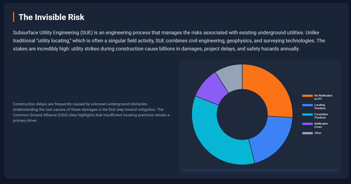
So far, it has been difficult to fully utilize AI to accelerate the process of mapping Singapore’s underground, simply because the density of objects buried here is extraordinarily high. The invisible infrastructure crisis that Deep Research alludes to in the United States of America is magnified in the 736.3km2 city-state of Singapore (barely a quarter the size of Rhode Island, USA’s smallest state). With land so limited, power, water, telecommunications, sewage, drainage, subways, carparks, industry and many other needs compete for space underground. Documentation has largely failed to keep pace, and utility agencies only provide the approximate locations of their subsurface assets on a need-to-know basis. Even with these drawings on hand, AI is yet to fully realize visual recognition, spatial reasoning, and multi-modal capabilities – asking Gemini or any other LLM to compile 40+ utility blueprints and compare it against EML location charts, GPR tomography, and trial hole 3D scans is akin to asking a child to compete in the Olympics; no matter how prodigious, AI lacks the experience and local knowledge to produce something even remotely good enough.
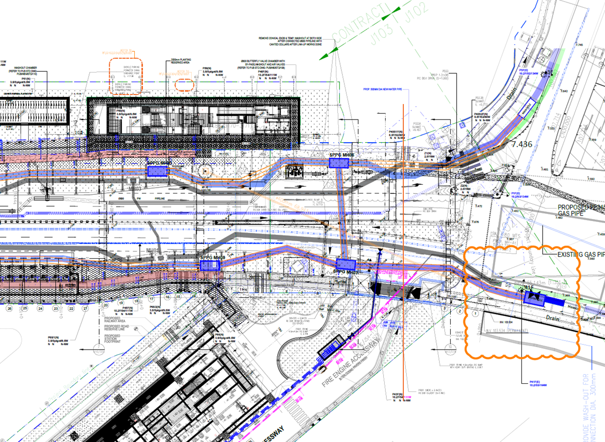 An example road junction in Singapore with various subsurface utilities and other structures in interlock
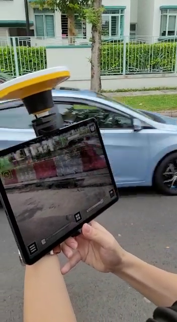
On the topic of drones, the airspace restrictions of Singapore are so complex that ad hoc drone use is just not financially or operationally feasible currently. Also known as the garden city, the tree density of Singapore is significant enough to impede air-based subsurface mapping. Drone-based GPR is also limited by reduced scanning depth and lower resolution due to signal attenuation from having a sizeable air gap between the scanner and the ground. Vehicle-mounted, pushcart, and stick-based scanners are still the workhorses for detection here.
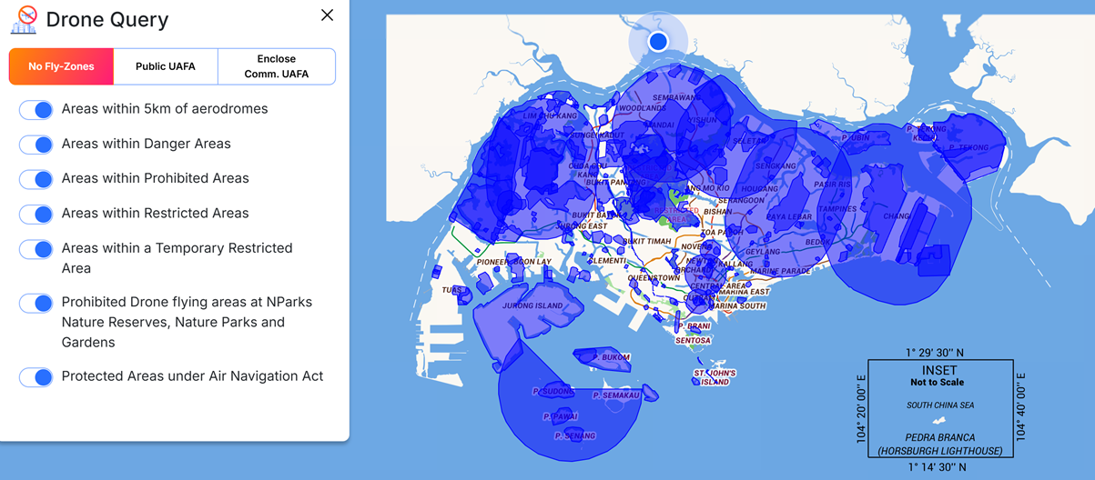 Active no fly-zones in Singapore cover almost the entire nation
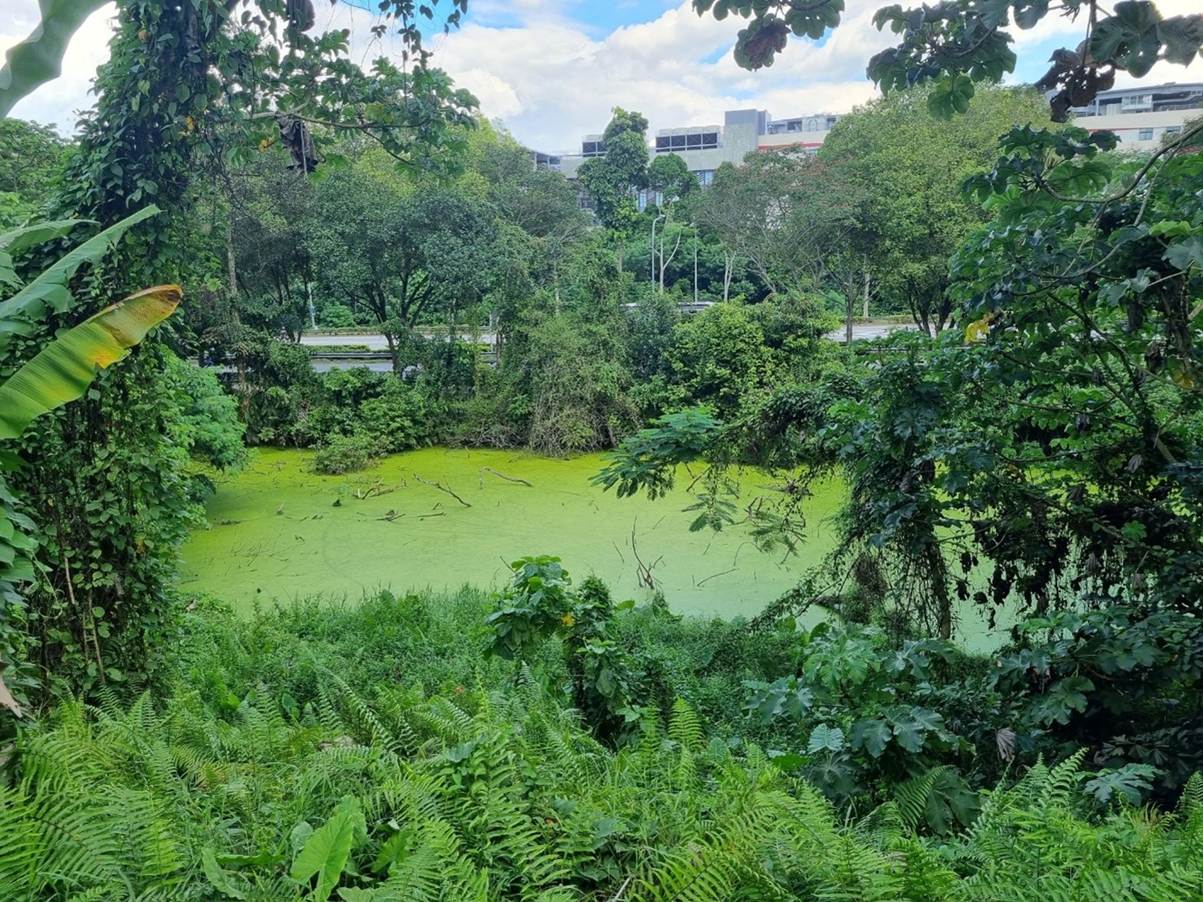 Typical jungle area in the reserved green zones of Singapore, next to a major road and industrial area
For AR, the key issue that needs to be solved for “x-ray” subsurface vision is occlusion. Humans have great intuition for distance and how objects should be “layered” when they pass one another – a car taking the long way around a building should disappear behind it while a car driving past right in front of you will continually remain in sight. The illusion that one can see a buried utility with AR is immediately broken when traffic (human, vehicular, or otherwise) and aboveground objects do not hide parts of the subsurface from view as they “rightly” should. AR solutions need to be lightweight, wireless, and intuitive enough so that field workers want to use it over more traditional methods (such a 2D drawings and trial digging) that are still more accurate in determining where space and objects are underground.
A car passes by while a display shows a past work site in AR. Proper occlusion should have the car travelling above the hole, in front of the water barriers, but instead it is concealed by the digital twin
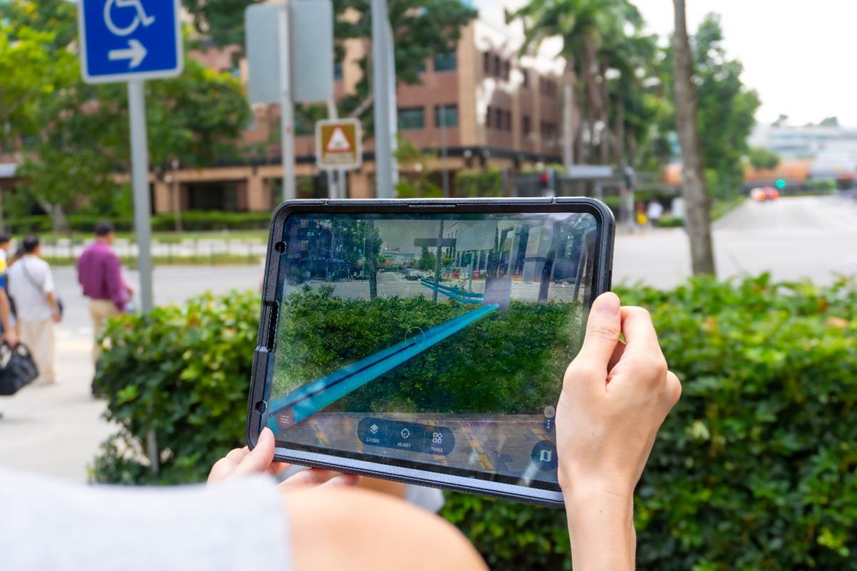 A display shows subsurface utilities at a busy road junction. Without occlusion, it is easy to misunderstand that the pipes are cutting through the bushes while in actuality they are buried several meters underground.
Overall, while Deep Research has correctly deduced that SUE is gaining importance, what it feels are key transformative technologies and legislations are less applicable in Singapore. A local partner is always better when you embark on a civil engineering project. Work with GeoPulse and See the Unseen.
About the Writer(s)

Foo Zhi Rui is a Power Apps Maker and Digital Technologies Journeyman. Here's his linkedin